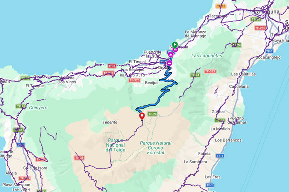
Santa Úrsula Climb is a point-to-point cycling route starting from Triciclos Canarias (Santa Úrsula). The track covers approximately 31.9 km, with 1,873 m of total ascent and 39 m of descent. Elevation ranges from…
Routeanalyse
Ken de route. En fiets hem.
Afstand
31,9km
Totale stijging
1.873m
Hoogste punt
2.128m
Laagste punt
294m
RouteafbeeldingSanta Úrsula Climb
Routeverloop
Kaart
Van punt naar punt
Hoogteprofiel
Hoogte
1366 routepunten
Beweeg over het profiel om afstand en hoogte te bekijken.
Meer dan de kerncijfers
Wat het spoor ons vertelt.
Berekend uit langere delen van het routebestand. Rijtijden zijn planningsschattingen, geen gemeten prestaties.
01
Geschatte fietstijd
Rustig
3h 10m
Gemiddeld
2h 30m
Sportief
2h 05m
02
Langste klim
29,0 km
1.829 m gestegen · ongeveer 6.3% gemiddeld
03
Zwaarste kilometer
13.4%
Begint rond km 3.6
04
Zwaarste 500 meter
15.7%
Begint rond km 4
05
Verdeling van het terrein
Klimmen
92%
Glooiend/vlak
5%
Dalen
3%
06
Routekarakter
Van punt naar punt
1.873 m klimmen per 100 km · hoogste punt bij km 31.9
Pas deze route aan
Maak hem passend voor jouw rit.
Maak een persoonlijke kopie zonder de originele Bike Point-route te wijzigen.
01
Rijrichting omkeren
Rijd hetzelfde traject in de tegenovergestelde richting.
!De download is een door de bezoeker aangepaste kopie. Controleer voor vertrek wegen, paden, toegang en weersomstandigheden.
Route-informatie
Santa Úrsula Climb is a point-to-point cycling route starting from Triciclos Canarias (Santa Úrsula). The track covers approximately 31.9 km, with 1,873 m of total ascent and 39 m of descent.
Elevation ranges from approximately 294 m to 2,128 m, with the highest point reached at about kilometre 31.9. Based on sustained track sections, roughly 92% of the distance is climbing, 5% is rolling or relatively flat, and 3% is descending. The longest detected sustained climb is approximately 29.0 km, gaining about 1,829 m at an average gradient of 6.3%; the hardest sustained kilometre averages approximately 13.4%. These figures are calculated from the supplied GPX track and may differ slightly from Garmin, Strava or Komoot because elevation smoothing methods vary.