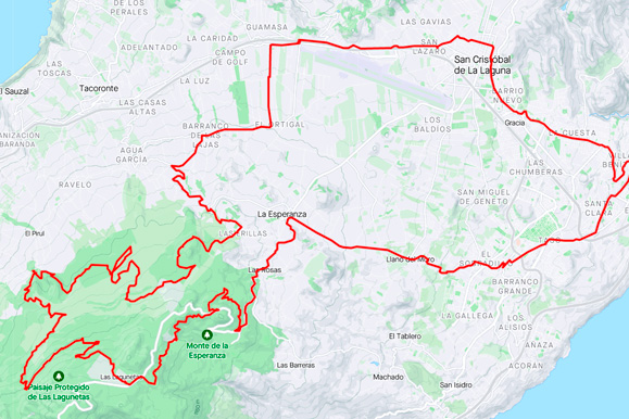
La Esperanza Long Gravel Ride is a loop cycling route starting from Tenerife North. The track covers approximately 77.9 km, with 1,974 m of total ascent and 1,977 m of descent. Elevation ranges from…
Track analysis
Know the route. Then ride it.
Distance
77.9km
Total ascent
1,974m
Highest point
1,325m
Lowest point
-10m
Route imageLa Esperanza Long Gravel Ride
Route trace
Map
Loop route
Climbing profile
Elevation
16816 track points
Move across the profile to inspect distance and elevation.
Beyond the headline numbers
What the track tells us.
Calculated from the route file using sustained sections rather than noisy point-to-point gradients. Riding times are planning estimates, not recorded performances.
01
Estimated riding time
Relaxed
6h 05m
Regular
4h 55m
Strong
4h 05m
02
Longest climb
30.0 km
1,116 m gained · approximately 3.7% average
03
Hardest kilometre
9.3%
Begins at approximately km 43.1
04
Hardest 500 metres
10.4%
Begins at approximately km 24.3
05
Terrain split
Climbing
38%
Rolling/flat
26%
Descending
36%
06
Route character
Loop
1,974 m climbing per 100 km · highest point at km 49.3
Adapt this route
Make it work for your ride.
Create a personal copy without changing Bike Point’s original route.
01
Reverse direction
Ride the same track in the opposite direction.
02
Choose a new start
For this loop route, choose another point on the trace as your start and finish.
!Your download is a visitor-modified copy. Check current road, trail, weather and access conditions before riding.
Route guidance
La Esperanza Long Gravel Ride is a loop cycling route starting from Tenerife North. The track covers approximately 77.9 km, with 1,974 m of total ascent and 1,977 m of descent.
Elevation ranges from approximately -10 m to 1,325 m, with the highest point reached at about kilometre 49.3. Based on sustained track sections, roughly 38% of the distance is climbing, 26% is rolling or relatively flat, and 36% is descending. The longest detected sustained climb is approximately 30.0 km, gaining about 1,116 m at an average gradient of 3.7%; the hardest sustained kilometre averages approximately 9.3%. These figures are calculated from the supplied GPX track and may differ slightly from Garmin, Strava or Komoot because elevation smoothing methods vary.