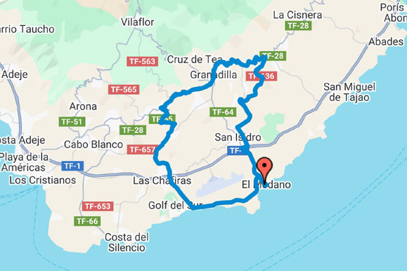
El Médano – Chimiche – San Miguel is a loop cycling route starting from Bike Point El Médano. The track covers approximately 45.9 km, with 800 m of total ascent and 797 m of…
Analyse du parcours
Découvrez le parcours. Puis parcourez-le.
Distance
45,9km
Dénivelé positif
800m
Point culminant
652m
Point le plus bas
1m
Image du parcoursEl Médano – Chimiche – San Miguel
Tracé du parcours
Carte
Circuit en boucle
Profil altimétrique
Altitude
1863 points du parcours
Parcourez le profil pour consulter distance et altitude.
Au-delà des chiffres clés
Ce que la trace nous révèle.
Calculé sur des sections continues du fichier. Les temps sont des estimations de préparation, pas des performances enregistrées.
01
Temps de parcours estimé
Tranquille
3h 20m
Régulier
2h 40m
Sportif
2h 15m
02
Plus longue ascension
21,6 km
644 m gagnés · environ 3% de moyenne
03
Kilomètre le plus difficile
6.1%
Commence vers le km 1.1
04
500 mètres les plus difficiles
7.2%
Commence vers le km 3.1
05
Répartition du terrain
Montée
34%
Vallonné/plat
34%
Descente
32%
06
Caractère du parcours
Boucle
800 m de montée par 100 km · point culminant au km 21.8
Adaptez cet itinéraire
Adaptez-le à votre sortie.
Créez une copie personnelle sans modifier l’itinéraire original de Bike Point.
01
Inverser le sens
Parcourez le même tracé dans le sens opposé.
02
Choisir un autre départ
Pour cette boucle, choisissez un autre point du tracé comme départ et arrivée.
!Le téléchargement est une copie modifiée par le visiteur. Vérifiez les routes, sentiers, accès et conditions météo avant de partir.
Conseils de parcours
El Médano – Chimiche – San Miguel is a loop cycling route starting from Bike Point El Médano. The track covers approximately 45.9 km, with 800 m of total ascent and 797 m of descent.
Elevation ranges from approximately 1 m to 652 m, with the highest point reached at about kilometre 21.8. Based on sustained track sections, roughly 34% of the distance is climbing, 34% is rolling or relatively flat, and 32% is descending. The longest detected sustained climb is approximately 21.6 km, gaining about 644 m at an average gradient of 3.0%; the hardest sustained kilometre averages approximately 6.1%. These figures are calculated from the supplied GPX track and may differ slightly from Garmin, Strava or Komoot because elevation smoothing methods vary.