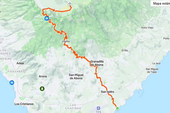
El Teide from El Médano is a point-to-point cycling route starting from Bike Point El Médano. The track covers approximately 48.7 km, with 2,399 m of total ascent and 272 m of descent. Elevation…
Streckenanalyse
Kennen Sie die Route. Dann fahren Sie los.
Distanz
48,7km
Gesamtanstieg
2.399m
Höchster Punkt
2.198m
Tiefster Punkt
8m
RoutenbildEl Teide from El Médano
Streckenverlauf
Karte
Strecke von A nach B
Höhenprofil
Höhe
1346 Streckenpunkte
Bewege dich über das Profil, um Distanz und Höhe zu prüfen.
Mehr als die wichtigsten Zahlen
Was die Strecke uns verrät.
Aus der Routendatei anhand längerer Abschnitte berechnet. Fahrzeiten sind Planungswerte, keine aufgezeichneten Leistungen.
01
Geschätzte Fahrzeit
Entspannt
4h 30m
Regelmäßig
3h 40m
Sportlich
3h 00m
02
Längster Anstieg
20,2 km
1.159 m Anstieg · etwa 5.7% im Durchschnitt
03
Schwerster Kilometer
9%
Beginnt ungefähr bei km 30.5
04
Schwerste 500 Meter
9.7%
Beginnt ungefähr bei km 30.9
05
Streckenaufteilung
Anstieg
79%
Wellig/flach
11%
Abfahrt
10%
06
Routencharakter
Strecke von A nach B
2.399 m Anstieg pro 100 km · höchster Punkt bei km 38.6
Route anpassen
Passend für deine Tour.
Erstelle eine persönliche Kopie, ohne die Originalroute von Bike Point zu verändern.
01
Richtung umkehren
Fahre dieselbe Strecke in der entgegengesetzten Richtung.
!Der Download ist eine vom Besucher geänderte Kopie. Prüfe vor der Fahrt Straßen, Wege, Wetter und Zugangsbedingungen.
Routenhinweise
El Teide from El Médano is a point-to-point cycling route starting from Bike Point El Médano. The track covers approximately 48.7 km, with 2,399 m of total ascent and 272 m of descent.
Elevation ranges from approximately 8 m to 2,198 m, with the highest point reached at about kilometre 38.6. Based on sustained track sections, roughly 79% of the distance is climbing, 11% is rolling or relatively flat, and 10% is descending. The longest detected sustained climb is approximately 20.2 km, gaining about 1,159 m at an average gradient of 5.7%; the hardest sustained kilometre averages approximately 9.0%. These figures are calculated from the supplied GPX track and may differ slightly from Garmin, Strava or Komoot because elevation smoothing methods vary.