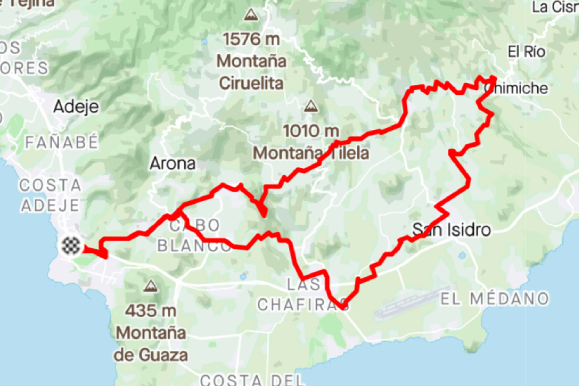
For this tour, you’ll start cycling north in direction of Santa Cruz, passing the view point of La Centinela. Once you pass Granadilla de Abona, you’ll start descending. In Chimiche you’ll turn around and…
Streckenanalyse
Kennen Sie die Route. Dann fahren Sie los.
Distanz
63,2km
Gesamtanstieg
1.228m
Höchster Punkt
654m
Tiefster Punkt
37m
RoutenbildBest of the south
Streckenverlauf
Karte
Rundroute
Höhenprofil
Höhe
1624 Streckenpunkte
Bewege dich über das Profil, um Distanz und Höhe zu prüfen.
Mehr als die wichtigsten Zahlen
Was die Strecke uns verrät.
Aus der Routendatei anhand längerer Abschnitte berechnet. Fahrzeiten sind Planungswerte, keine aufgezeichneten Leistungen.
01
Geschätzte Fahrzeit
Entspannt
4h 45m
Regelmäßig
3h 45m
Sportlich
3h 10m
02
Längster Anstieg
17,2 km
615 m Anstieg · etwa 3.6% im Durchschnitt
03
Schwerster Kilometer
7.7%
Beginnt ungefähr bei km 9.9
04
Schwerste 500 Meter
8.9%
Beginnt ungefähr bei km 9.9
05
Streckenaufteilung
Anstieg
34%
Wellig/flach
30%
Abfahrt
36%
06
Routencharakter
Rundkurs
1.228 m Anstieg pro 100 km · höchster Punkt bei km 21.6
Route anpassen
Passend für deine Tour.
Erstelle eine persönliche Kopie, ohne die Originalroute von Bike Point zu verändern.
01
Richtung umkehren
Fahre dieselbe Strecke in der entgegengesetzten Richtung.
02
Neuen Start wählen
Wähle bei dieser Rundstrecke einen anderen Punkt als Start und Ziel.
!Der Download ist eine vom Besucher geänderte Kopie. Prüfe vor der Fahrt Straßen, Wege, Wetter und Zugangsbedingungen.
Routenhinweise
For this tour, you'll start cycling north in direction of Santa Cruz, passing the view point of La Centinela. Once you pass Granadilla de Abona, you'll start descending. In Chimiche you'll turn around and take some more local and calmer roads all the way back to our Las Americas shop. The perfect route for an easy day on the bike with some short climbs.